https://hcggis.harfordcountymd.gov/planning/harfordgis/
How to use:
- Open the link in your search browser
- Enter the address you’re looking for in the search bar
- Interactive icons on the bottom of the page can help you find answers to several frequently asked questions at the Harford County Health Department-Environmental Health.

What kind of soil types (classification) does my property have?
- First, find your property by address.
- Click on the blue circle icon with data layers. (Looks like a sandwich) A pop up area will appear to the left.

- Next click on Base Mapping, a drop-down list appears.
- Finally, scroll down to find the check box for Soil Classification, then click the check box.
- Now your map will have a colorful indicator of soils.
If you go on to the Harford County Health Department webpage, you can identify and classify your soil or tell the time the soil shall be tested. Click here for the soil chart.
Also included on this map, after clicking on Data Layers:
- Contours
- Hydrology lines
- Hydrology polygons
- Streams
- Ponds
Looking for Satellite images? Click the orange circle icon with four squares.

Print your image: Select the print icon at the bottom of the page

How to generate a PDF for printing in scale: (Print button allows a draft PDF to be processed)
After selecting the print icon, Click on the drop down for Layout.
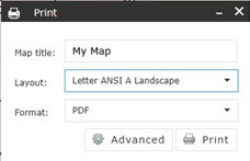
Select Letter ANSI A (Either landscape or Portrait)
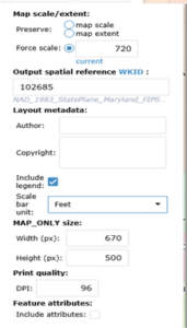
Click on Advanced, you will see the following pop-up box:
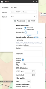
Make selections as follows:
Click the radio button for Force Scale and enter the correct scale as follows:
For 1” = 40’, enter 480, For 1” = 50’, enter 600, For 1” – 60’, enter 720, For 1” = 80’, enter 960
Output spatial referenced WKID, enter 102685
Layout metadata: Scale bar unit, select FEET
Click Print
A PDF will appear on the pop-up box showing 1. My Map
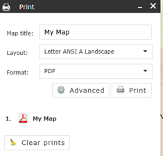
Click 1. My Map
Your PDF will pop up allowing you to print your map.
